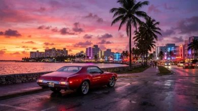
Rockstar Games has officially revealed the high-resolution state map of Leonida for Grand Theft Auto VI, putting an end to years of speculative cartography and community coordinate stitching. The official transit and tourist map confirms a geographic landmass more than twice the size of Grand Theft Auto V’s Los Santos and Blaine County combined. Spanning five administrative counties, multiple maritime archipelagos, trans-state interstate highways, and vast wilderness reserves, Leonida represents the most geographically complex sandbox ever constructed in interactive entertainment.
Map Scale, Coordinate Grid, and Geographic Boundaries
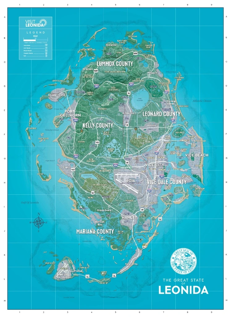
The official Leonida document features an authentic cartographic grid ranging from latitude lines A through M and longitude coordinates 1 through 9. A printed scale index on the top-left legend establishes that 1 inch equals 0.5 miles (2 inches per mile), providing definitive mathematical context for the continent’s physical dimensions.
Unlike previous entries where cities functioned as isolated oceanic islands surrounded by endless open water, Leonida is framed as an authentic continental peninsula. The landmass is bounded by the Atlantic Ocean to the east, the Gulf of Leonida to the west, and the treacherous Leonida Straits to the south. Players exploring the open waters will encounter severe maritime weather, deep-sea drop-offs, and dynamic nautical currents that affect boat handling and aerial navigation.
Five Administrative Counties of Leonida
Rockstar has organized the state of Leonida into five distinct governing counties, each operating with dedicated law enforcement jurisdictions, municipal infrastructure, economic tiers, and distinct NPC populations.
1. Vice-Dale County: The Metropolitan Epicenter
Occupying the southeastern coastline, Vice-Dale County serves as the economic and cultural crown jewel of Leonida. Anchored by the sprawling urban expanse of Vice City, this region features dense commercial skyscrapers, vibrant nightlife strips, luxury beachfronts, and heavy industrial cargo docks.
- Vice City Metro: Divided into distinct neighborhood sectors including Downtown Vice City, Ocean Beach, Vice Beach, Little Cuba, Tisha-Wocka, and the VC Port container terminal.
- Maritime Enclaves: Exclusive gated island properties including Starfish Island, Venetian Islands, and Prawn Island, accessible via drawbridges and high-speed waterways.
- Aviation Gateway: Vice City International Airport (VCIA), featuring commercial dual runways, private executive hangars, and automated security perimeters.
- Transit Spine: Direct connectivity to Interstate 404, US Route 1A, US Route 97, and Route 35.
2. Kelly County: Industrial Docks and Underworld Hubs
Positioned along the western gulf coast, Kelly County is a gritty, blue-collar antithesis to Vice City’s neon glamour. Dominated by container yards, shipping warehouses, manufacturing facilities, and coastal industrial refineries, Kelly County serves as the western terminus for statewide logistics.
- Port Gellhorn: The industrial core of western Leonida, featuring freight train staging, massive container cranes, and heavy criminal syndicates.
- Emerald Springs and Gellhorn: Inland blue-collar neighborhoods filled with dive bars, chop shops, and local black-market trade networks.
- Capri and Draper Island: Coastal barrier outposts offering tactical chokepoints and secluded docks for waterborne contraband.
- Transit Connections: Western origin of Interstate 404 and intersection with State Route 183.
3. Leonard County: The Agricultural Heartland
Situated directly north of Vice-Dale County along the eastern Atlantic coastline, Leonard County transitions from coastal suburban luxury to expansive rural farming plains and country club estates.
- Ambrosia: A bustling rural hub known for agricultural produce, freight depots, and working-class diners.
- Belville: A quiet bedroom community positioned along the central highway corridor, featuring suburban strip malls and local police precincts.
- Waning Sands: A scenic, windswept stretch of Atlantic beachfront catering to surfers, seaside motels, and coastal vacationers.
- Leaf Links: High-end luxury golf clubs and country club estates bordering the northern edge of Vice City.
4. Lummox County: Northern Mountain Wilderness
Dominating the entire northern frontier of the map, Lummox County introduces dramatic vertical terrain, dense timberlands, and treacherous off-road trails. This region marks the highest elevations in the state, offering complete isolation from municipal police response.
- Mount Kalaga National Park: A protected natural reserve featuring rugged peaks, deep river gorges, mountain hiking trails, and dangerous apex predators.
- Grayson and Bonanza: Remote northern settlements housing independent survivalist enclaves, hunting lodges, and secluded dirt airstrips.
- Millport and Lake Leonida: An expansive freshwater lake system supporting commercial freshwater fishing, hydroelectric infrastructure, and Richard Farbrooke State Park.
- Northern Islands: Isolated offshore landmasses including Hyde Island, Little Marion Island, and Periwinkle Bay.
5. Mariana County: Tropical Swamps and the Keys Archipelago
Forming the southern base of Leonida, Mariana County is a hazardous wilderness of murky swamplands, mangrove mazes, and tropical ocean keys connected by extended maritime viaducts.
- Grassrivers: An untamed, alligator-infested swamp system navigated primarily by fan-powered airboats. Law enforcement presence vanishes entirely deep inside the interior wetlands.
- Hamlet and Watson Bay: Stilt-house fishing communities, airboat rental docks, and remote bait shops operating off the municipal grid.
- Key Lento and Southwind: The tropical island archipelago stretching southwest into the Gulf of Leonida, famous for offshore wreck diving, luxury yachts, and sport fishing.
- Mile Zero Air Station: The southernmost military and civilian aviation strip, serving as an isolated refueling outpost at the end of the Overseas Highway.
Statewide Transit Arteries: Interstates and Highways
Navigating Leonida requires understanding the primary federal and state highway systems marked clearly across the official cartography:
| Route Designation | Origin / Terminus | Counties Traversed | Strategic Value |
|---|---|---|---|
| Interstate 404 | Port Gellhorn to Vice City | Kelly, Lummox, Leonard, Vice-Dale | Primary east-west high-speed transit artery for supercars and cross-map escapes. |
| US Route 35 | Southern Mariana to Northern Lummox | Mariana, Vice-Dale, Leonard, Lummox | Central north-south spine bisecting the heartland through Ambrosia and Millport. |
| US Route 97 | Vice-Dale to Northern Leonard | Vice-Dale, Leonard | Eastern coastal express corridor connecting downtown metro to Waning Sands. |
| US Route 1A | Vice City to Mile Zero | Vice-Dale, Mariana | The iconic Overseas Highway spanning open-ocean bridges down the Keys archipelago. |
| State Route 183 | Capri to Central Kelly | Kelly | Western regional connector linking Port Gellhorn with rural wetlands and coastal bluffs. |
| State Route 628 | Grayson to Millport | Lummox | Northern perimeter mountain pass wrapping around the base of Mount Kalaga. |
Trending Player Hotspots: Solving Key Location Mysteries
Following the map reveal, players and community trackers have pinpointed several critical mission locations and high-interest landmarks that have dominated viral search queries:
Where is Mandy’s House located? Analysis of the road grid places Mandy’s residence in the suburban transitional zone along the boundary between northern Vice-Dale County and western Leonard County, accessible via secondary residential streets branching off US Route 35.
Strip Club and Nightlife Locations: The official map confirms two distinct nightlife epicenters. The gritty, high-heat Nine Nine club is established in the industrial container district of Port Gellhorn in Kelly County, while premium high-end VIP lounges operate along the neon-lit strip of Ocean Drive in Vice-Dale County.
Map Unlocking and Fog of War Mechanics: Unlike earlier Rockstar titles where physical bridges were blocked by arbitrary roadblocks, Leonida’s entire landmass is physically accessible from the start. However, the radar and in-game map remain shrouded in a dense fog of war. Players can clear regional fog rapidly by chartering high-altitude aircraft or systematically traversing major highway arteries in land vehicles.
PFD Editorial Context and Gameplay Synergies
The scale of Leonida directly underpins the revolutionary survival, heist, and character-switching systems detailed in our GTA 6 gameplay master guide. Because local police remember clothing combinations and vehicle profiles across individual county lines, knowing exact county borders allows players to shake intense multi-star heat by crossing into neighboring jurisdictions where local patrol frequencies reset.
Furthermore, running massive open-world streaming across five distinct biomes requires optimized console hardware. Ensure your PlayStation 5 🏆 storage and network firmware meet the mandatory threshold outlined in our GTA 6 required PS5 system software update to prevent texture pop-in across high-speed interstate corridors.
With Grand Theft Auto VI dominating industry headlines and leading The Game Awards 2026 nomination slate with eight historic nods, Rockstar’s cartographic reveal demonstrates that Leonida is not just an aesthetic playground, but an unprecedented benchmark for open-world simulation and emergent gameplay.
Stay Ahead in the Tech World
Join our community for breaking news, exclusive gadgets coverage & direct admin support.